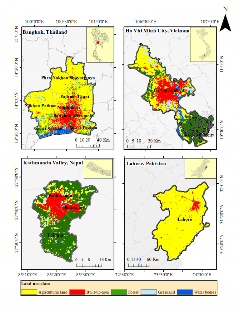
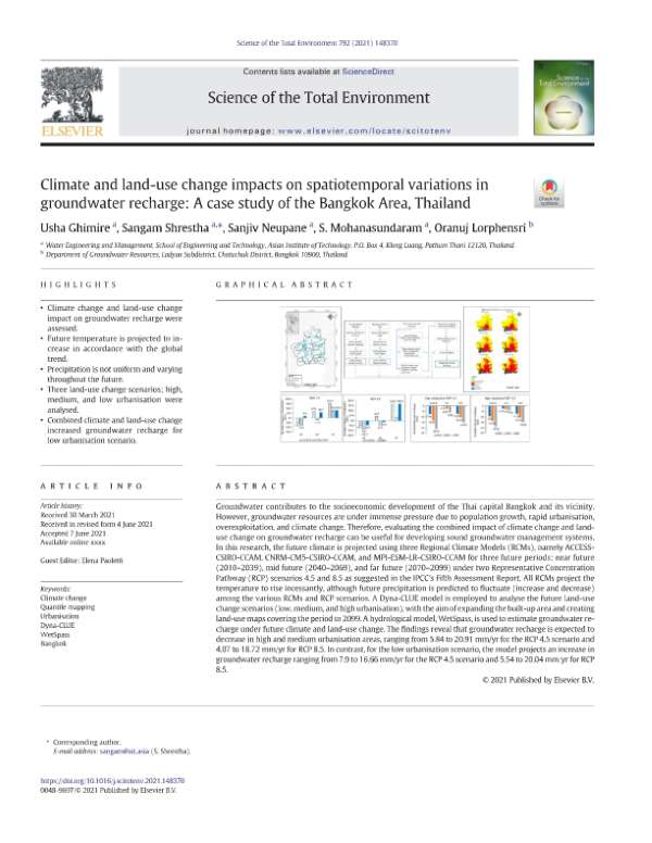
Groundwater contributes to the socioeconomic development of the Thai capital Bangkok and its vicinity. However, groundwater resources are under immense pressure due to population growth, rapid urbanisation, overexploitation, and climate change. Therefore, evaluating the combined impact of climate change and land-use change on groundwater recharge can be useful for developing sound groundwater management systems. In this research, the future climate is projected using three Regional Climate Models (RCMs), namely ACCESS-CSIRO-CCAM, CNRM-CM5-CSIRO-CCAM, and MPI-ESM-LR-CSIRO-CCAM for three future periods: near future (2010–2039), mid future (2040–2069), and far future (2070–2099) under two Representative Concentration Pathway (RCP) scenarios 4.5 and 8.5 as suggested in the IPCC’s Fifth Assessment Report. All RCMs project the temperature to rise incessantly, although future precipitation is predicted to fluctuate (increase and decrease) among the various RCMs and RCP scenarios. A Dyna-CLUE model is employed to analyse the future land-use change scenarios (low, medium, and high urbanisation), with the aim of expanding the built-up area and creating land-use maps covering the period to 2099. A hydrological model, WetSpass, is used to estimate groundwater recharge under future climate and land-use change. The findings reveal that groundwater recharge is expected to decrease in high and medium urbanisation areas, ranging from 5.84 to
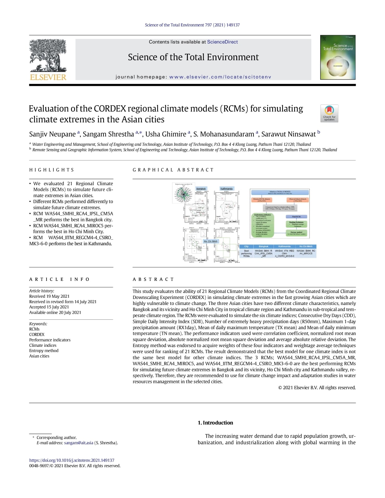
This study evaluates the ability of 21 Regional Climate Models (RCMs) from the Coordinated Regional Climate Downscaling Experiment (CORDEX) in simulating climate extremes in the fast growing Asian cities which are highly vulnerable to climate change. The three Asian cities have two different climate characteristics, namely Bangkok and its vicinity and Ho Chi Minh City in tropical climate region and Kathmandu in sub-tropical and tem-perate climate region. The RCMs were evaluated to simulate the six climate indices; Consecutive Dry Days (CDD), Simple Daily Intensity Index (SDII), Number of extremely heavy precipitation days (R50mm), Maximum 1-day precipitation amount (RX1day), Mean of daily maximum temperature (TX mean) and Mean of daily minimum temperature (TN mean). The performance indicators used were correlation coefficient, normalized root mean square deviation, absolute normalized root mean square deviation and average absolute relative deviation. The Entropy method was endorsed to acquire weights of these four indicators and weightage average techniques were used for ranking of 21 RCMs. The result demonstrated that the best model for one climate index is not the same best model for other climate indices. The 3 RCMs; WAS44_SMHI_RCA4_IPSL_CM5A_MR, WAS44_SMHI_RCA4_MIROC5, and WAS44_IITM_REGCM4-4_CSIRO_MK3-6-0 are the best performing RCMs for simulating future climate extremes in Bangkok and
Groundwater resources of Kathmandu Valley in Nepal are under immense pressure from multiple stresses, including climate change. Due to over-extraction, groundwater resources are depleting, leading to social, environmental, and economic problems. Climate change might add additional pressure by altering groundwater recharge rates and availability of groundwater. Mapping groundwater resilience to climate change can aid in understanding the dynamics of groundwater systems, facilitating the development of strategies for sustainable groundwater management. Therefore, this study aims to analyze the impact of climate change on groundwater resources and mapping the groundwater resiliency of Kathmandu Valley under different climate change scenarios. The future climate projected using the climate data of RCM’s namely ACCESS-CSIRO-CCAM, CNRM-CM5CSIRO-CCAM and MPI-ESM-LR-CSIRO-CCAM for three future periods: near future (2010–2039), mid future (2040–2069) and far future (2070–2099) under RCP 4.5 and RCP 8.5 scenarios were bias-corrected and fed into the Soil and Water Assessment Tool (SWAT), a hydrological model, to estimate future groundwater recharge. The results showed a decrease in groundwater recharge in future ranging from 3.3 to 50.7 mm/yr under RCP 4.5 and 19–102.1 mm/yr under RCP 8.5 scenario. The GMS-MODFLOW model was employed to estimate the future groundwater level of Kathmandu Valley. The model revealed that the groundwater level